
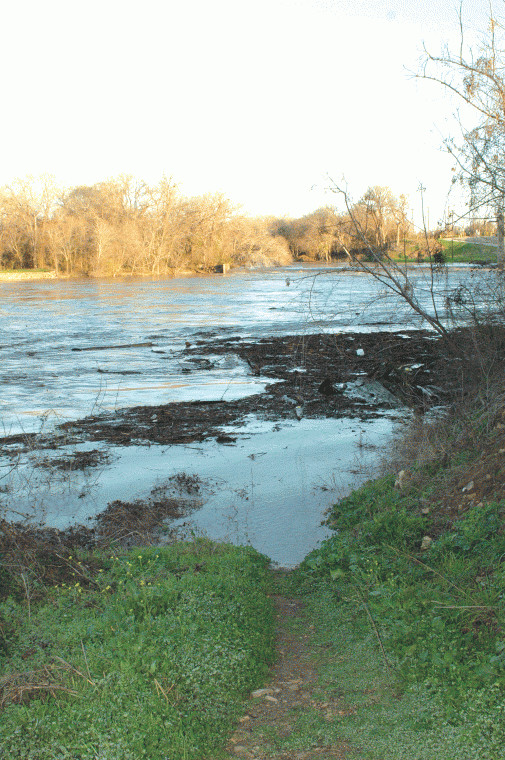
Floodwaters swallow Gonzales lowlands
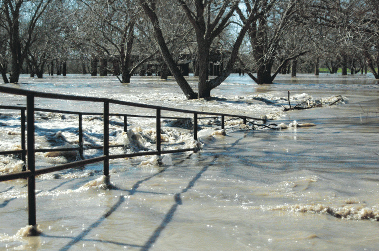
The Guadalupe River overflowed its banks by midday Thursday, as the swift-moving, muddy water inundated most of Independence Park and floodwaters swelled to more than 40 feet -- 9 feet over flood stage -- by late afternoon.
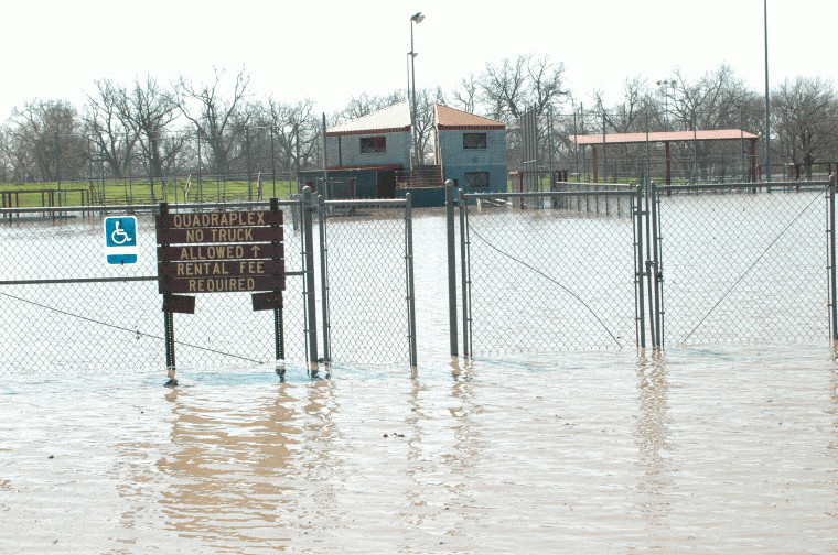
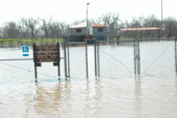
The baseball facilities at the Quadraplex in Independence Park were inundated when the Guadalupe River exceeded its 31-foot flood stage.

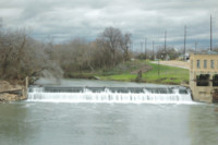
Water was rushing over the spillway at the old power plant at 4 p.m. Wednesday. The Guadalupe River is expected to swallow up the spillway by late Thursday.
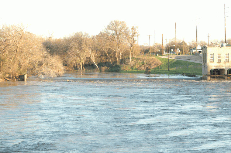
By 8 a.m. Thursday, the spillway was almost unrecognizable as the Guadalupe River reached 29 feet, just 2 feet below flood stage.

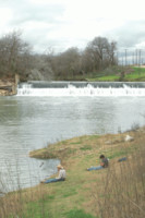
Two young fisherman anticipated the rise of the river -- and increased chances for better fishing -- at 4 p.m. Wednesday.
By 8 a.m. Thursday, the banks of the Guadalupe River below the spillway were flooded, a stark contrast to just 12 hours earlier.


Although Independence Park and other
low-lying areas in and around Gonzales bore a striking resemblance
to a lake Thursday afternoon, residents in the Guadalupe River
flood plain are breathing a collective sigh of relief today after
initial warnings from the National Weather Service proved
inflated.
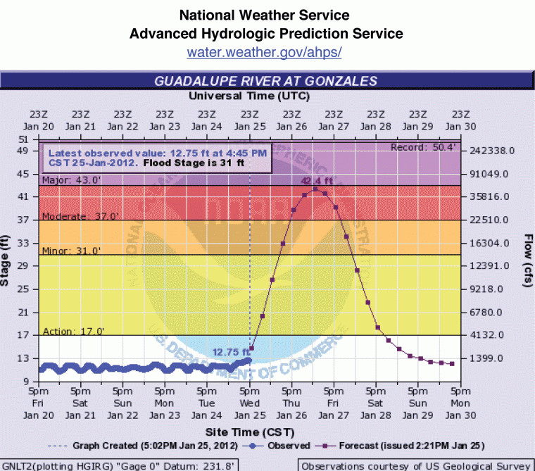
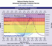
The Guadalupe appeared to have crested in
Gonzales at midday Thursday, reaching more than 37 feet according
to the NWS Advanced Hydrologic Prediction Service. Observers
indicate that the river crested at 37.11 feet at 1:45 p.m.
Thursday, almost five feet above flood stage. The flood gauge at
the old Gonzales Hydro Station registered a river depth of 37 feet
at 1 p.m.
According to Jimmy Harless, Gonzales County
Emergency Management coordinator, the river is expected to remain
at or above flood stage into Friday before waters recede into
Saturday.
The NWS Austin-San Antonio, after issuing a
flood warning on Wednesday for the Guadalupe River in Gonzales
County to reach major flooding levels of more than 42 feet,
downgraded its predictions on Thursday, saying river levels should
exceed flood stage, but only by about four feet.
Wednesday’s warning called for waters to
reach more 42.3 feet — a whopping 11 feet above flood stage, with
widespread flooding expected and scenarios that would have threaten
to close U.S. Highway 183 and state Highway 97.
But Paul Yura with the NWS said Thursday
that minor — rather than major — flooding was expected. The NWS
revised its forecast for the river to rise above flood stage,
predicting the river would surpass the 31-foot flood stage
Thursday. The river is expected to fall below flood stage by late
Friday.
As of presstime Thursday evening, much of
Independence Park remained under water and had attracted scores of
curious onlookers throughout the day clamoring to witness the
phenomenon that belies drought concerns. Widespread flooding was
also reported in rural low-lying areas, especially surrounding
Ottine in northwest Gonzales County. There was also at least one
instance of a northwest county resident’s truck being swept off the
roadway near Ottine. That truck was under up to 10 feet of water by
midday Thursday.
When the NWS flood models predicted major
flooding if the river reached 43 feet, it was feared U.S. Highway
183, state Highway 97 and FM 108 would be closed. Runoff down
Tinsley Creek in Gonzales would have added to the Guadalupe River
backwater, flooding the lowest homes near the river.
At 8 a.m. Thursday, the Guadalupe River was
reported to be at 29 feet, up almost 17 feet from its 12.4-foot
level midday Wednesday. As the river rose above flood stage, the
lowest homes near the waterways, as well as secondary roads and
streets near the river, were in danger of flooding and were
expected to be dangerous to motorists.
Many persons along the river began
evacuation preparedness arrangements Wednesday night when initial
reports indicated major flooding in all but the highest parts of
the county.
The San Marcos River in Luling was well
above flood stage by Wednesday afternoon, swelling to almost 33
feet, which was 13 feet above flood stage. It is expected to recede
to near normal levels by Saturday morning. The Guadalupe River
flooding in Gonzales surpassed the Luling flood stage by up to four
feet.
In anticipation of the Guadalupe River
exceeding flood stage, the NWS Advanced Hydrologic Prediction
Service issued the following scenarios as to what to expect as the
river surpassed the 31-foot mark.
At 31 feet (flood stage), minor lowland
flooding begins to enter Independence Park south of the
spillway.
At 34 feet, pastureland northwest of
Gonzales between the Guadalupe and San Marcos rivers is flooded.
The lowest areas of Independence Park flood.
By the time the river level hits 37 feet,
moderate lowland flooding would inundate pasture and cropland
between the Guadalupe and San Marcos River confluence and Gonzales.
Secondary roads, low bridges and much of Independence Park and
facilities near the Guadalupe River in Gonzales are flooded.
At 40 feet, moderate lowland flooding
inundates a large area of pastureland northwest of Gonzales between
the Guadalupe and San Marcos rivers. Highway 183 has water going
over the bridge, likely closing the highway. Much of Independence
Park in Gonzales is flooded, with lowest areas under up to 9 feet
of water. Many secondary roads in the flood plain are flooded and
closed.
In the original forecast of the river
reaching 43 feet, major flooding would have closed highways 183 and
97, and FM 108 as runoff from Tinsley Creek in Gonzales would have
added to the Guadalupe River backwater, causing flooding of the
lowest homes near the creek. Secondary roads and streets near the
river would also flood and be dangerous to motorists.
At 45 feet, the river flow reaches the floor
of the old power plant and to the slab of the electric plant. Water
is several feet deep in the baseball park and concession buildings
in Independence Park. Flooding is several miles wide in the flood
plain just northwest of Gonzales. Flow approaches lower homes in
the Tinsley Creek flood plain in Gonzales as the Guadalupe River
backs up. Any flow down Tinsley Creek over the backflow can flood
homes.
At 48 feet, the flow passes through the
windows of the old power plant. All highways into town are flooded
except Highway 97 north. Nearly all Independence Park is under
several feet of water. The flood plain northwest of Gonzales below
the Guadalupe-San Marcos Rivers confluence is several miles wide.
The lowest homes along miles of Tinsley Creek are flooded as the
Guadalupe River backs into it.
The record for the Guadalupe River in
Gonzales is 50.44 feet, which occurred Oct. 17-18, 1998. It is the
highest level ever reached since recordkeeping began in 1905.


Comments